 Constant change in landscapes, cities, and shorelines demand accurate, up-to-date understanding of environments and resources. Kinetics Geospatial delivers geospatially precise visual representations of the earth for any area of interest, applicable for base-maps and an array of derived product applications.
An Orthoimage is an aerial photograph which has been geometrically corrected / rectified to conform to a uniform scale, and that also has been adjusted for distortion / elevation / topographic relief using a digital elevation model (DEM). Orthos are important resources for mapping and geospatial professionals because they display the rich, detailed information represented in photographs (but without distortion), and are an accurate representation of the Earth’s surface—and similar to a map orthos can be used for measuring true distances.
The section below displays a selection of orthoimagery samples from various Kinetics Geo projects. To see additional Kinetics Geo sample imagery—or for more information about how we can help make your next orthoimagery project a success—contact us today via email or call us at 407.501.8375.
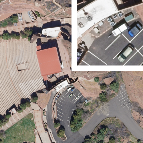
DENVER REGIONAL AERIAL PHOTOGRAPHY PROJECT (DRAPP)
3-INCH ORTHOIMAGERY—1467 SQUARE MILES
6-INCH ORTHOIMAGERY—1225 SQUARE MILES
2020 & 2022
Kinetics Geospatial was selected for a second time to produce a high quality ortho-image mosaic over the Denver front-range area. The larger 3-inch resolution area of 1467 square miles was tied seamlessly into the surrounding 1225 square mile 6-inch resolution area.
All production was completed under the strict guidelines of the Denver Regional Council of Governments (DRCOG).
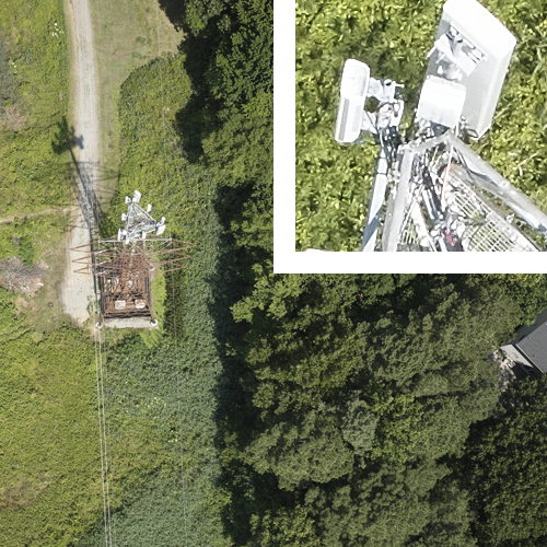
MISSOURI / KANSAS CORRIDOR MAPPING
POWER LINE CORRIDOR ORTHOIMAGERY / LiDAR PRODUCTION—
1,500+ MILES
2017-2023
Kinetics Geospatial mapped over 1,500 miles of powerline corridors in the states of Missouri and Kansas in 2022 using both LiDAR and ortho-imagery. The ortho-imagery was processed at a 3-inch resolution for delivery and was also used to support the classification and planimetric extraction of features in the LiDAR. Dozens of features were classified, and vectors were extracted, including but not limited to buildings, walls, signs, light poles, railroads, sidewalks, roads, manholes, bridges, swimming pools, ditches, creeks, water bodies, transmission lines, distributions lines, poles and towers. In addition, Kinetics Geo processed meteorological data and ingested the final products into PLSCADD.
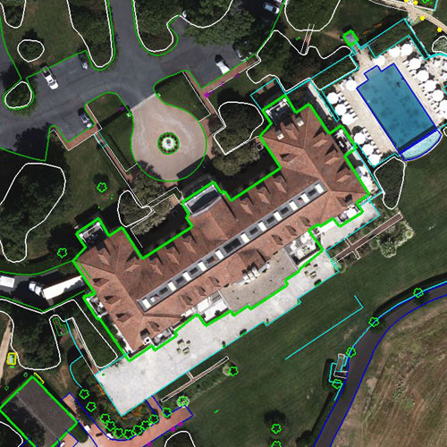
CITY OF SEATTLE STEREO COMPILATION
3-INCH RESOLUTION ORTHOIMAGERY—2 SQUARE MILES
2018
Kinetics Geospatial performed full 3D planimetric collection using stereo compilation methods to meet the City of Seattle CAD standard for an area encompassing two square miles in the heart of Seattle. For this project, Kinetics Geo collected over 90 unique features—from land use features such as roads and buildings, to land cover features such as landscaping and water.
Kinetics Geo orthos are a key component of the basemaps used in many public and private GIS databases, and a variety of products, mapping tools, and databases can be derived from our orthos. These ortho-derived products support analysis, planning, and decision-making for applications such as: transportation, land-use/land-cover, assessment / change detection, wetlands, soil, parcel mapping, agriculture, forestry and other natural resources. In addition, Kinetics Geo orthos also can be combined further with digital elevation data for 3D modeling / slope and terrain analysis.