Markets We Serve
At Kinetics Geo, our geospatial experts use cutting-edge orthoimagery and LiDAR acquisition technologies supported by industry-leading processing technologies and techniques. This achieves project results that save time and control costs. Our customers come to us from across a broad spectrum of markets and business sectors for best-quality, precision geospatial data and derived products that can be applied to addressing real-world challenges and concerns.

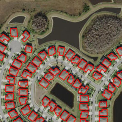
Urban Planning
Actionable data for modeling and visualization are critical for analysis and planning needed to build sustainable urban and suburban communities. Kinetics Geospatial delivers high-resolution Orthoimagery, high-density LiDAR data, and and array of derivative products and services designed to support regional and local planning, environmental impact studies, regulatory compliance, emergency response planning, and land use / land cover analysis.
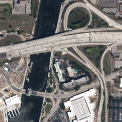
Transportation and Infrastructure
Kinetics Geo orthoimagery and LiDAR data enable visualization of assets and environments relative to the planning, design, construction, upgrade, and maintenance of transportation and infrastructure elements associated with roadways, bridges, railways, and airports and plays a critical role in managing the transportation infrastructure life cycle. In addition, it helps ensure effective safety management, environmental studies, and land use decisions.
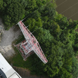
Energy
Companies in the energy development and utility provider industries rely on aerial imagery and LiDAR data to assist in route / location studies for transmission line placement, siting for wind, telecommunication, and solar infrastructure, and for surveys of existing infrastructure. Aerial imagery / LiDAR data also are effective for environmental implact studies, emergency management planning, and risk assessment.
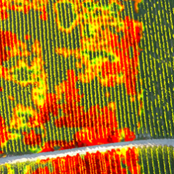
Agriculture
Modern mapping and imagery analysis technologies have become indispensible tools for contemporary agricultural concerns. Kinetics Geo aerial imagery and derived products provide the data critical for analysis by agricultural GIS applications to help monitor crop health, estimate yields, and maximize production. In addition, determinations may be made about a location’s specific soil types, condition, slope, aspect, and elevation.
Assessment
Orthoimagery and derived products are vital for assessment professionals’ processes and workflows. When implemented as a powerful, information-rich component of a GIS installation, orthoimagery base maps facilitate accurate analysis of property value and help implement improvements in land and property tax administration. This enhances fairness, and transparency in government tax administration.

Natural Resources and Forestry
Forests are a dynamic natural resource, influenced by natural processes and human management strategies. Orthoimagery helps forest management professionals make informed decisions and improve efficiencies in management activities. Kinetics Geo products play a vital role in forestry resource management, vegetation studies, wildfire mitigation, and mapping for reforestation after logging or fire.
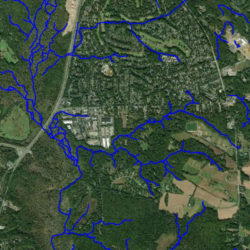
Hydrology
Kinetics Geo utilizes LiDAR and orthoimagery to map and model surface water storage and surface water flow over large areas. Remote sensing also allows us to measure soil moisture, study aquatic vegetation, and model flood inundation.
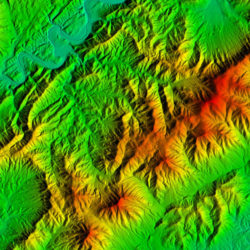
Terrain Analysis
LiDAR and LiDAR derived products are extremely useful in terrain analysis. Kinetics Geospatial is capable of utilizing LiDAR for landslide detection, fault analysis, generating contours and measuring slope and elevation.